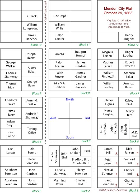
Mendon Plat Map of 1863
This modern view of the J. H. Martineau, Cache County Surveyor, second map of Mendon, Utah drawn on October 29, 1863, is taken from the original drawing and support data from the Cache County court house. The blocks numbered one to nine below are the original nine blocks that were surveyed when Mendon was first settled in 1859. The “ground zero” survey point for all of Mendon City is on the southeast corner of the public square, block five. The main County Road enters the city from the north on what we now know as First West, turned east on Center Street and then left Mendon, south toward Wellsville on Main Street for several blocks before jogging east again to First East and then out of town. This map as constructed below, was first made in 1984 and worked on from that time until the printing of “Isaac Sorensen’s, History Of Mendon. ” This map was offered for inclusion in the “book” but the map on the page opposite 75 showed up instead along with a copy of James H. Martineau’s original map which I had found on page 448.
Prior to this map on August 10, 1859 Jesse W. Fox Sr., surveyor from Salt Lake City, surveyed and laid out the old fort, also the fields adjoining the town. The starting point of the community was know and the general location of the first nine blocks. However due to the Indian troubles at this time they moved into the fort and lived in this manner until 1864, when they went out onto their 'city' lots as recorded and noted by the county. The following link is a complete listing of the support data that accompanied this map: Lot Owners. Some of the entries have been updated and are from a later time.
![]()